
Mexico City and surrounding cities, the capital of Mexico, which covers an area of approximately 7,800 square kilometers (3,000 square miles) and is home to about 22 million people, were built on the bottom of an ancient lake.
Many streets in the city center were formerly canals, and this tradition continues in the outskirts.
Mexico City has been subsiding for over 100 years as the aquifer has rapidly diminished due to large-scale groundwater pumping and urban development. Many monuments and older buildings, such as the Metropolitan Cathedral, whose construction began in 1573, are noticeably tilted.
The contraction of the aquifer has caused chronic water shortages, a problem expected to worsen in the future.
"This is damaging Mexico City's major infrastructure, including the subway, drainage system, water supply, drinking water supply system, housing, and roads," said Enrique Cabral, a geophysics researcher at the National Autonomous University of Mexico.
"This is a very serious problem."
Mexico City is sinking so rapidly that the subsidence can be observed even from space.
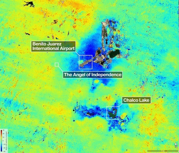
According to a recent report released by NASA, ground subsidence is occurring at an average rate of 2 cm (0.78 inches) per month in some areas, with major airports and the iconic monument widely known as the "Angel of Independence" being examples.
Overall, this amounts to approximately 24 cm (9.5 inches) of ground subsidence per year. According to Cabral, the ground has sunk more than 12 meters (39 feet) in less than 100 years.
"We are one of the regions in the world experiencing the fastest rate of ground subsidence," he said.
These estimates by NASA are based on data used by the NISAR satellite, a joint project between NASA and the Indian Space Research Organization (ISRO), to track changes in the Earth's surface in real time from October 2025 to January 2026.
NISAR scientist Paul Rosen stated that by capturing detailed views of the Earth from space, "we can also obtain information about what is actually happening beneath the surface."
"This data basically records all the changes that occurred within the city," Rosen said.
He added, "You can fully grasp the severity of the problem."
The research team hopes to observe specific areas in greater detail over time and eventually obtain measurements for each individual building.
Furthermore, the researchers hope to apply this technology globally to track natural disasters, changes in fault lines, and the impact of climate change in regions such as Antarctica.
Rosen stated that this technology could be used to enhance warning systems. For instance, it would allow scientists to notify the government of the need for evacuation in the event of a disaster, such as a volcanic eruption.
According to Cabral, for Mexico City, this technology represents a significant step forward in studying ground subsidence issues and mitigating the worst-case scenarios.
Related Article: New Survey Shows 28 Most Populated Cities in the U.S. Are Sinking
For decades, the Mexico City government has largely neglected this issue, aside from reinforcing the foundations of monuments like the cathedral.
However, Cabral revealed that government officials have begun increasing funding for the research as water shortages have recently worsened. Images and data obtained from the NISAR satellite will play a key role in helping scientists and officials plan solutions to the problem.
Cabral said, "For long-term problem mitigation, it is important to understand the situation first and foremost."


0 Comments